Wednesday, October 20, 2010

here are the pictures for Wed., 10/20

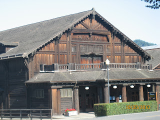
a building in 'downtown' Scotia

now THAT was a biggun!

museum in Scotia

jacaranda?  Just guessing

lovely wood everywhere in Scotia

can't drive Dan's truck through, but my car would fit!


nice memorial for Vietnam vets


unbelieveable!!

my man, Dan!


Dan is 6/2 - look at the size of that tree!


yes, I'm standing INSIDE the tree!

tree houses, really!


wednesday, 10/20, northern California

Wednesday, October 20, 2010
Today, we woke up by the bay in Eureka to what I'm told is the usual morning fog.  We just left out as the fog should be dissipating.  A few miles down the road, suddenly, it was a clear, sunny day.  What a difference!
Dan took me to a little town called Scotia.  Owned by a lumber company that process redwood trees.  Cool little town, neat houses all in a row, lovely buildings made of the redwood.  Very nice veterans' memorial - I took pictures of the Vietnam plaque that was there...very touching.
We drove through the "Avenue of the Giants".  I thought I was prepared to be amazed by the size of the redwoods, but the sheer immensity, grandeur, beauty, cathedral-like beings were overwhelming!  It felt as though we should whisper while on a walk through an old growth part of the forest - I can understand why primitive man might worship those trees!  Instead, I was awed by the sheer size and beauty of those living creatures that God created.  They rise to way over 300 feet! One measurement I read was 64 feet in circumference!!  Factoid:  they are absolutely straight - Why?  Of course, partly because they reach to the sun, but as it turns out, they straighten themselves by strategically putting out branches!  One redwood, pointed to by the sign on this subject, was leaning, and a new branch went out on the side away from the lean so that it is now straight!  These trees are something you just have to see to begin to conceive of it!
We stopped at one vineyard in the redwood area, tasted some wine, bought some wine, and continued on.
We left the redwoods completely behind at Willet - mountain roads, up, down, twisty, to beautiful views, and all of a sudden, the vegetation was totally different - no redwoods, some clear land with dry grasses, different and much smaller trees.
Once down from the mountains, we entered wine country - vines growing everywhere.  We came up behind one semi carrying huge open containers filled with little round green grapes.  Lovely homes, a different vinyard every mile or even less at times.  All their tasting rooms were closed, so we'll be forced to do some tasting tomorrow as we enter the Napa valley!

Tuesday, October 19, 2010

California, here we come!

Tuesday, October 19, 2010
One thing we noticed here in Oregon, as opposed to Washington, the clear cutting of the forrests (which I have been assured is good for the forest and land) still is done, but they leave about 50 yards on either side of the highway - you can see through that band, but it certainly looks much better!
We drove through the rest of Oregon and into California, camped in Eureka near the Avenue of the Giants (redwoods).  All along the Oregon coast, there were so many heart-stopping, breathtaking views, I can't begin to categorize or capture them.  We have a schedule to keep, so couldn't stop as often as we would have liked.  We did stop a few times, took a few pictures, and enjoyed the drive (well, Dan drove, I rode). 
We saw some bicyclists on the road - amazing.  In Oregon, we saw a couple of bridges and a tunnel, where the bicyclist is to press a button upon entering to activate a warning blinker for vehicle drivers.  Pretty cool.  But, with the 2 lane road being, in some places, barely wide enough for cars, it seems terrifying to me for those bicycle riders!
Once in California, one road sign was a little different:  they still say "Tsunami Warning Zone" with a picture of a big wave, but there's no little cartoon guy scrambling up a hill to escape!  What's that about??
We've begun to see some huge redwoods, but they're only a fraction of the size of the really big ones!  I can't wait to see them tomorrow.
Big day tomorrow, gotta go!
Tues morning near Beverly Beach, Oregon

those rocks look like humpback whales!

ok, I can't eliminate any more - here they are..Oregon sites


Cape Blanco - most westerly point in contiguous states


wind blow much here??

another lighthouse

Oregon coast - wow!

Monday, October 19, 2010
At the south end of Washington state, drove through an area hit by a hurricane in 2007 - huge area where all the trees were knocked down and salvaged by the Wyerhauser Company. They have replanted much of the area already, and smaller trees cover the scars of the devestation There were signs along the road that told about the hurricane, salvage operationm, and replanting (ie "Hey, don't blame us, we're cleaning up a mess made by the hurricane.")
All along the and even down the highway in the little town of Raymond are silhouette-type scultures of all sorts of animals, people standing, with children, on bicycles, in canoes - all dressed or adorned in pink (in honor of Breast Cancer Awareness Month). Very nice.
Factoid (courtesy of Dan): a slough looks like a small stream or river, but is strictly an inlet from the ocean, with the salt water coming in and out with the tide. In Virginia, the same thing is called a creek.....In Alabama, a creek ('crik') is a small stream, not just tidal!
We stopped at the Lewis and Clark National Park, looked at the fort (replica of what the expedition built for wintering here). We have been intrigued by the trees in this region, and I finally broke down and bought a tree book! The trees are amazing - HUGE, diverse, beautiful: hemlocks, Sitka spruce, redcedar.
We met a couple from New York who have the same type of camper as ours, and talked to them for quite a while. The guys talked guy stuff, electronics, gadgets, features. The women talked about the travel experiences. They live in their camper 7 months out of each year! They have been to 49 states, all the Canadian provinces, all over Mexico - they love the life, and Whave been doing that for years. They've been doing truck camping (started when their children were 2 and 4) for 45 years! Interesting, fun people - I'm so glad we met.
Ecola State Park, recommended by both our travel book and a friend, was spectacular. The view was described as the most beautiful on the west coast - I can see why. I could sit there all day! Took lots of pictures, and I'm going to have trouble picking my favorites for the blog...there was a trail leading down (way down) to the beach. We took it as far as seemed prudent (at ages 61 and 63). Dan actually thought hard about that last 30 yards (down a muddy bank using a knotted rope) I didn't consider it, valueing my intact bones as I do. As it was, we both got a bit muddy (left foot, right foot, WET foot!).
Continuing on south on Hwy. 101, Oregon is as pretty as I imagined it to be. Most of the time, we are beside the water. One stretch, we were high above a very wide, sandy beach, very narrow road, no shoulder, with a stone wall to keep you from going over the cliff. For a while, the road went somewhat inland, through farmland, very tall forests, and still with those majestic mountains in view.
We saw some unusual road signs today:
-Rock (?)
-Slides
-Tsunami Hazard Zone (with a cartoon-like drawing of a huge wave about to overrun a guy clawing his way up a hill) -- Yikes!
-Tsunami Evacuation Drill, 10/21, 3 pm -- Ditto!
-Entering a Tsunami Ready Community
We also saw (but it was closed) the Tillamuck Air Museum, housed in the largest wooden structure in the world (!) It certainly was a massive building, housing derrigibles and other really big aircraft.
Had a great oyster dinner in Newport, OR. Stopped for fuel, where the attendant (?) asked 1.) What could he get us, and 2.) May I wash your windshield!!!! Whhhhat? We both said “Are you kidding?” Turns out in Oregon (and in New Jersey), it is illegal for you to pump your own gas….who knew?
Enough for now - we’re stopping in Newport, OR for the night.
Lewis & Clark Natl Park - huge trees - see the people for reference!


pretty path down to the water

stood on path and pointed camera straight up (way up!)

old posts left in water from logging days-used to sort and funnel timber

close up of moss all over this tree.

from cliffside in Ecola State Park - words fail me...

famous Haystack Rock

for size reference, see teeny person by rocks near bottom of picture....

Wind blow much here??

path down to the beach

Dan,ready to rappel down the muddy bank....

Somebody mows this - can't figure how they'd get in there!!

Sunday, October 17, 2010

one last picture from today (Sunday)

the very happy couple!

More of the Olympic Peninsula

Sunday, Oct. 17, 2010
Left Port Angeles this morning, driving along Hwy. 101.  Rivers, lakes, mountains - beautiful country.  We stopped in a store for a cup of coffee, and started looking at some books signed by the author, Ron Pond - just reading random pages, we were both howling with laughter.  So, that potty/coffee stop cost about $45!
Lake Crescent, 8 miles long and 625 foot deep, is another fjord-like lake, surrounded by mountains.  It is such a calm lake, unlike our large lakes in Michigan, that beautifully mirrors the surrounding mountains, trees. 
We have decided to take a 35 mile detour from Hwy 101, on Hwy 113 and 112, that will take us to the most northwest corner of the lower 48 states, Cape Flattery. 
In a few days, we'll be in San Diego, and we'll go to the most southwest corner.  We're already thinking about other trips we'll go on to cover the other two corners.  So many places to go, so little time!
After we left the Olympic National Forest, we started to see some areas where the land was in some stage of clear cutting, burning, replanting - mountains looked like a dog with a bad haircut!  It may be necessary (I'm not sure), but it sure isn't pretty.
The road out to Neah Bay and Cape Flattery is absolutely beautiful:  much of the way, the strait is in view; much of the way, we drove through a stunning tunnel of trees (think lush, very lush vegetation); all twisty andd turny, up and down.  The last part is through the Makah Indian Reservation.  To get to Cape Flattery, we drove 8 miles past Neah Bay to the trailhead.  About 3/4 miles of well-maintained trail to the actual Cape - well worth the trip.  We ate our lunch there, enjoyed the view which was magnificent today!  The man at the Makah Museum said that the normal weather for this time of year is gray, with horizontal rain and winds from 10 to 70 knots!  Today, it was clear and probably in the 60's, so our view: of the Strait of Juan de Fuca, with Canada to the north; the Pacific Ocean and the  cliffs and caves around the cape; and Tatoosh Island with its lighthouse was stunning.  Funny, if the weather had been 'normal' for here, we wouldn't have wanted to come to this spot - today, we didn't want to leave!
Driving south, we have passed miles and miles of beautiful, white, wide, sandy beaches as pretty as any in Florida - just add lots of trees, streams, and mountains to the east!  There are so many things we'd like to do here, places to see and experience, but we have to get moving south!  We're aiming for Hoquiam, WA tonight, on Grays Harbor (if Dan doesn't get too tired).  There's a campground there with WiFi - important information for me, since I have been requested to Skype Declan and Ella tomorrow morning!  Declan promised me a hug on Skype - I wouldnt miss that for the world!
OK,so we just drove through a town named "Humptulips" - I'm not making this up!  The town consisted of a few houses and Humptulips Grocery Store.  While wondering what in the world could have prompted someone to name a place Humptulips, we crossed over Humptulips River.  OK, so it must have been someone a loooooong time ago.  It's still a strange name.
Camped for the night in Hoquiam...tired.  Posting this, then shower, then night night!

moss covered tree fell, then grew around other tree?

think it's damp here?

morning sun coming over the mountains

morning shot


Lake Crescent

lovely Lake Crescent - smooth!

a herd of these animals in the field - anyone have any idea of what it is??  elk ladies??

view from near Neah Harbor (Canada over the water)

path to Cape Flattery

more trail to Cape Flattery

lush growth everywhere


from overlook near Cape Flattery

from overlook near Cape Flattery (#2)

Near Cape Flattery (#3)


cool tree - ??

not quite there yet...


this one's from Cape Flattery


Pacific Ocean from Cape Flattery

Tattoosh Island (& lighthouse) off Cape Flattery

Vancouver Island and Strait of Juan de Fuca


Tattosh Island off Cape Flattery